
They all looked promising. Very promising. Boulder caves, cracks, potential beginnings of paths deeper underground. But no, the scale was all wrong. We could not judge the scale in the barren landscape. Every single time we approached the cave holes it turned out that they are tiny holes between rocks, not massive cave openings like they looked from afar.
Jarmo and I wondered why that was the case. Maybe the rock in this area is easily broken to small pieces. Or broken through the harsh weather conditions. And instead of large boulders leaving a lot of space between themselves, the rocky landscape is filled to the brim with small rocks that fill all potential holes between other rocks. Does anyone know?
But back to the beginning. As part of our exploration trip to the Njiellalanjávri area, Duncan, Jarmo and me scouted all possible cave holes around lakes Njiellalanjávri, Toskaljärvi, Veajetjávrrit, and Láfoljávri lakes, and the mountains in between. We also scouted for limestone (see separate article).
However, as noted we did not really find particularly good caves. We did of course visit the known proper cave, the Toskaljärvi underground river cave. But it is full of water and running too fast for either us or even divers to enter. The rest... at best few of the largest ones could be called perhaps "cavelets" -- undersize caves that are still worth reporting, but are not really proper caves, sometimes only fitting one person if that.
Nevertheless, for the sake of carefully documenting everything, this article goes through each of the potential places we explored. Here's a map of all of them:
The above map is also available as a google maps collection (click here).
Then to our list of caves, in chronological order we looked at them:
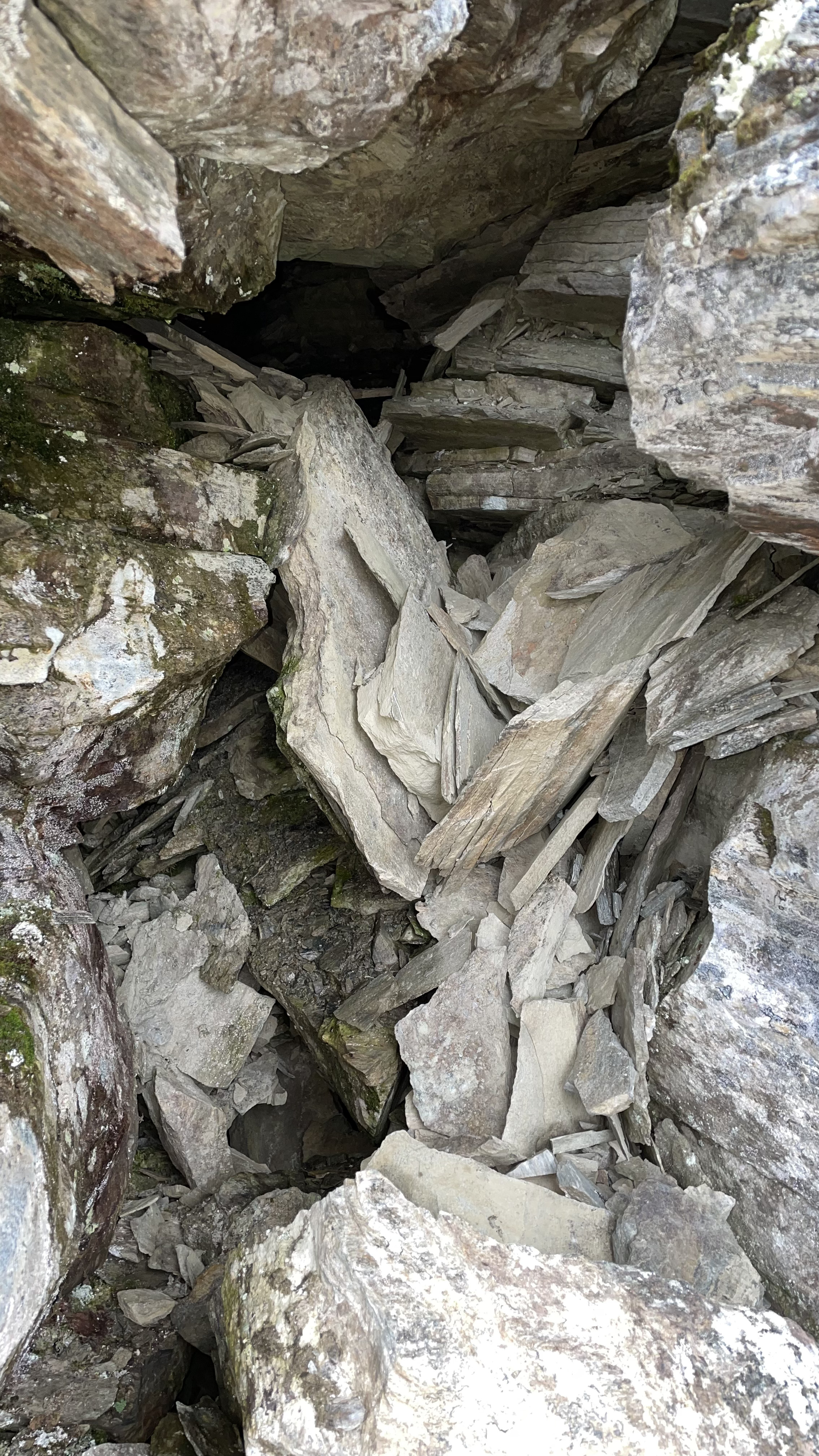
This canyon was a very nice find. Interesting rock, layered, cracking, leaning shaky stacks of rocks. The canyon is maybe 2-5 meters deep and runs for 100+ meters. At one point the cracked rocks are shifted so that there's a discontinuity in the canyon. There's a middle stack of rocks between the two sides, and under one side of the leaning stack there's a small hole. In addition, both walls of the canyon lean in, further covering the area where the small hole begins. Really nice place. I'd classify this as a small cavelet.
Photos (see also the top picture in the beginning of this article):
I also recorded a 3D model of this cave. You can view it
here or download it
here. And using my autogenerating map software,
Cave Outliner, I also generated the below map.
Given the small scale of the cave and the limited accuracy of the sensor in the iPhone I'm using, the map is not particularly high-resolution, but should give you an idea. And the Cave Outliner software is not perfect, it cannot always recognize entrances or driplines properly, so the map was manually edited for the entrance part. And the length of the cave has been also manually determined, in this case based on how far the small end of the cave at the bottom is from the dripline.
(For the web image vs. high-res file formats and the complete map rather this one picture, see the PDF version of the map, which is
here.)
This is the famous underground river. Nice, but no visitors welcome :-) except maybe fish. Or done submarines... mind boggles.
Photos:
The potential resurgence area for any caves in the mountains between Njiellalanjávri and Toskaljärvi is a large cliff with a boulder field at the bottom. Two of the largest boulders form kind of a tiny shelter. Too small for a proper cave, but registering it here for completeness sake.
I saw a hole, and climbed towards it. That may have been mistake, because at the end was very steep and very sketchy. But I made it almost up, and safely (?) down. However, I also did not dare to peek into the cave, given how sketchy the place was at the top. Or even reach out to take a photo, because I wanted to hold on to the so-so handholds with both of my hands.
But I think the didn't lead much further, though I can not be sure without properly looking in. So... still wondering.
There's a multi-stage waterfall falling down from the cliffs to the fields before Toskaljärvi. At the top of the cliff there are some large boulders, with some space underneath. Classifying this as a small cavelet.
6.
Láfolvárrit ridge door cave: Coordinates:
N 69.214629 E 21.441580. Length: 0.5 m. We saw this cave while the rain was pouring on us in the middle of storm. And indeed we were on a high plateau... in the darkness of the night I could not even take out my phone to take a photo, we continued hiking back to the camp that was still several kilometers away. But it look extremely promising. A door-shaped opening on a cliff face, with nothing but blackness behind! We had some trouble finding this place the next day when Jarmo and I returned to the site, but we did eventually identify it. Sadly, in day's light it turned out that it was indeed door shaped, but very shallow, maybe barely enough for a person to stand in it but .. yeah, maybe 40 or 50 cm deep :-)
This is not a big by any means, but it is maybe the nicest looking cave hole that we were able to find at least. There's a dry stream bed running down from the ridge, and at this spot there's a crack goes into the cliff, providing some shelter.
Photos:
I also recorded a 3D model of this cave. You can view it
here or download it
here. I again also generated a map, below.
(For the web image vs. high-res file formats and the complete map rather this one picture, see the PDF version of the map, which is
here.)
A tiny crack in the cliff where there's a part of the cliff that is more towards the front side of the cliff than elsewhere. The part in the front and the cliff leave a small crack in between.
On the other side of the same part as in side crack 1, there's a slightly larger crack. The crack also leads further down (but perhaps not wide enough for a human). The crack is also on top of the clear limestone rock layer (see the other
article).
At the bottom of the ridge cliff, there's a tiny roof cave. It is tiny, only 0.90 meters deep at the widest place and 0.95 meters high. But still 7.5 meters long. Maybe a borderline cavelet.
A couple of boulders forms some space underneath. Too tiny to classify as anything except boulders.
This is a small roof cave where the cliff provides some shelter underneath. But in front there's a large boulder (perhaps broken off from this spot) that shields the protected area from the front. The remaining space between the sheltered cliff and the rock is very narrow though.
The cave size is roughly 2.4 meters long x 0.6 meters wide and 1.0 meters high.
This a tiny roof cavelet on the cliff face, maybe three meters high from the ground. It is tiny in the sense of not going deep into the cliff or giving much shelter from rain, where I measured at the biggest spot, 1.1 meters high and 1.2 meters deep. But it is long in the other direction, over ten meters. Classifying this as a cavelet. Borderline though, given that it doesn't go much into the cliff. It doesn't feel like cave.
Photos:
This is a medium-sized crack, and from one side the rock leans over, forming also some roof over the crack. One can go inside. I would classify this as a tiny cavelet.
The crack is 3.2 meters long and 0.40 - 0.70 meters wide.
Photos:
This is a boulder, and under one side there may be a slight amount of shelter from the rain. Really minor, not a cave by any means.
This is a nice crack in the cliff with a roof on top. Sadly, it is tiny, not enough space to go inside. Not a cave.
On the slope from Láfolvárri top towards Njiellalanjávri there's a small cliff or perhaps pile of boulders on top of each other. Some space forms underneath.
The cave main part is 2.20 meters wide, 1.2 meters deep, and 0.6 meters high. But facing the cave from the front there's also a side space on the left, not included in those numbers.
On the cliff near the Láfoljávri lake there's a triangular hole. Too small to register as a cave of any sort.
At first, this was VERY scary. From few tens of meters away, it looked like there was a skeleton in a cliff crack. With the rib cage clearly visible.
A bit closer I realized that the "rib cage" was actually folding rocking layers, kind of like an open book pages bending nicely on top of each other. Phew.
Still, an odd rock to see!
By the way, between the triangle hole and paper hole there's a nice small canyon, in coordinates N 69.230038 E 21.377016.
This is on the col when walking from Njiellalanjávri towards the Kopmajoki hut, between Veajetoaivi and Skaidi. It is basically a small leaning rock pieces on a small cliff face, enough to form a tiny roof cavelet. But not officially a cave.
Photos:
I also recorded a 3D model of this cave. You can view it
here or download it
here. I also generated the below map.
(For the web image vs. high-res file formats and the complete map rather this one picture, see the PDF version of the map, which is
here.)
There are several small boulder and crack holes in this area, but all small. We took no pictures of these.
Read more urban exploration stories from theurbanexplorer.net, and other underground stories from planetcaver.net. Read the full Planetskier series at planetskier.net, or all blog articles from Blogspot or TGR. Photos and text and coordinates (c) 2023 by Jari Arkko, Jarmo Ruuth, and Duncan Simey. All rights reserved. Map base is from Maanmittauslaitos per CC BY 4.0, modified with the markings.


No comments:
Post a Comment