Saturday, December 2, 2023

Caves of Castel Gandolfo


I had an opportunity visit Castel Gandolfo recently. While I had been there briefly before, it was clear that there'd be more to explore. Castel Gandolfo sits on the rim of the lake Lago Albano, and also near Lago di Nemi. These lakes are beautiful places but also with interesting geology, both being volcanic craters.

But are there caves?

My primary target was to visit Grotta Neolitica (N 41.753270 E 12.684480). However, it turned out to be very difficult to reach. Access to it is on a steep hill and the cave itself is in the middle of a high cliff. It would have been possible to park the car near switchback where there's reportedly a path towards the cave. However, it just looked like an absolute jungle, overgrown bushes that would be difficult to pass through. No sign of any path visible. And as noted, this was on a steep hill. Contrary to my usual bad judgment, I decided it was too dangerous.

If anyone's interested, there's a Wikiloc path leading to it -- the one I was trying to find. 

Photos below. In the first picture, the cave is on the other side of the lake, in the cliffs at the top of the rim roughly in the middle.

It turned out that my first cave visit would be in an unexpected place: the dinner restaurant. Arte e Vino is a very nice restaurant in Castel Gandolfo's main street. Coordinates are N 41.745297 E 12.650869. While waiting to be seated, we were offered a tour of their cave -- a complex maze of underground rock tunnels under their basement. The maze connects a number of different restaurants on both sides of the street, and to this date houses their wine collections, vegetables, and all kinds of historic equipment for wine-making and other purposes. The cave is in part a built basement on the upper part, then a in part a human-carved set of tunnels and in part natural cave holes. Very interesting! Wish I had something like this under my house :-)

Photos:

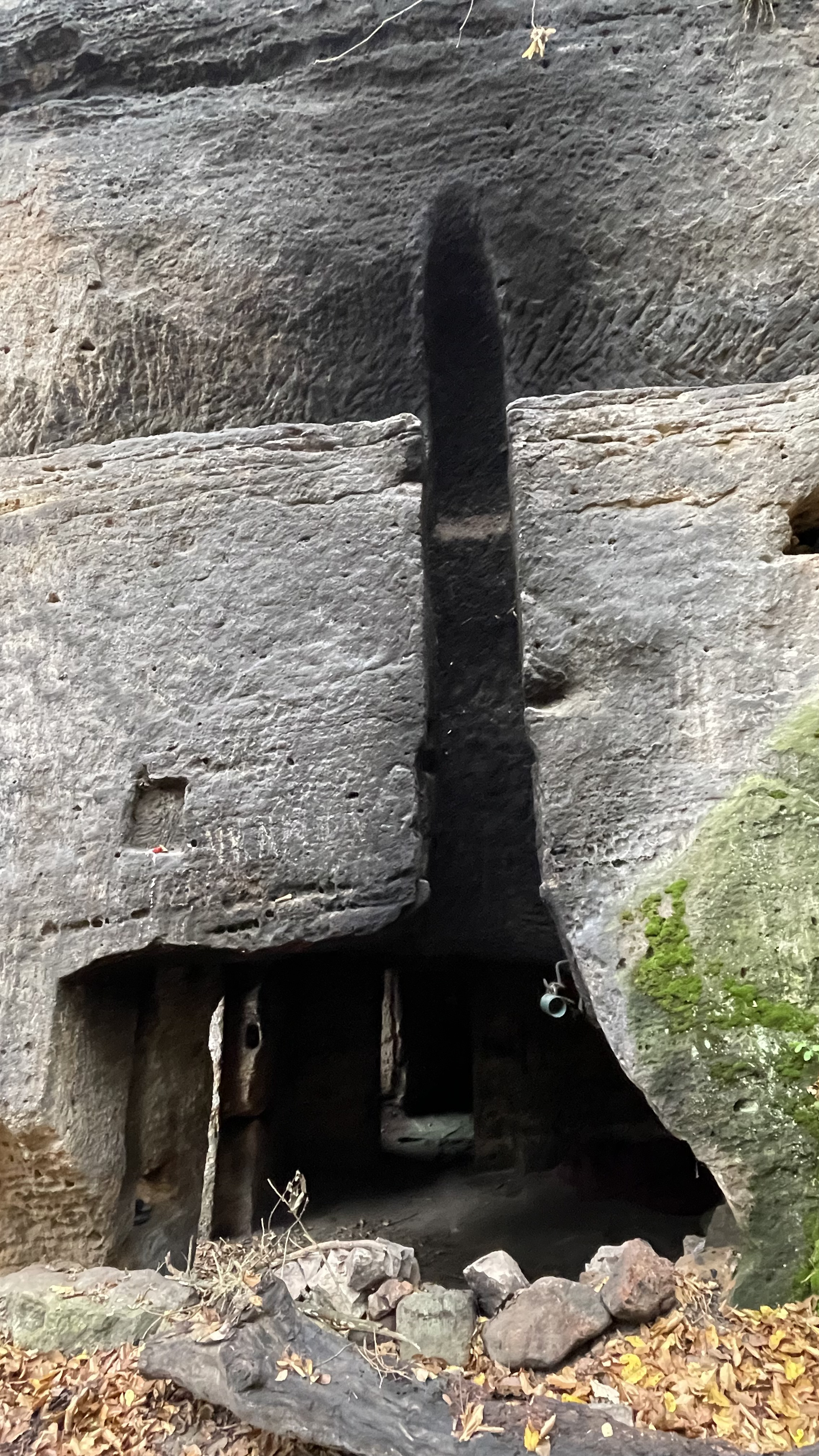
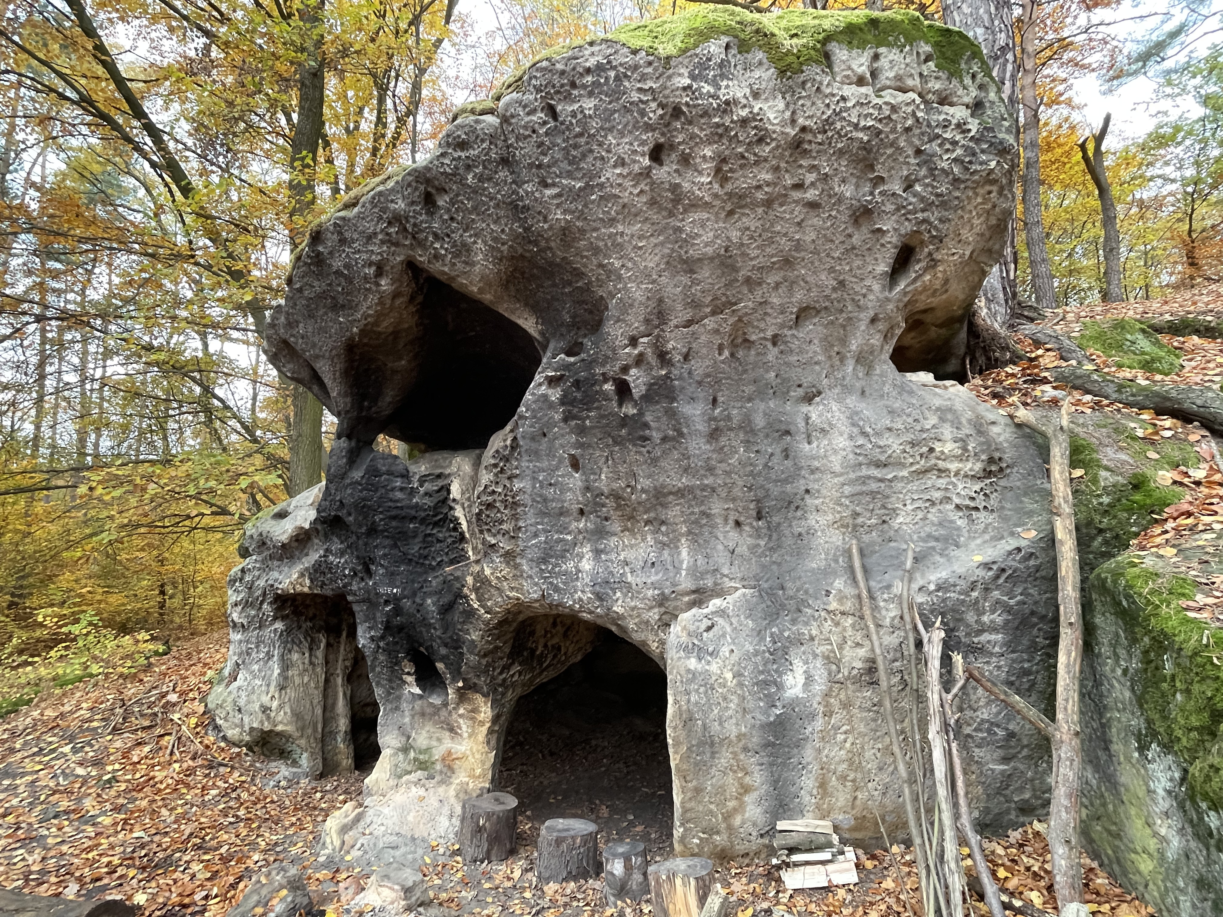
But on the way to Grotta Neolitica I had also spotted something by the road. In the backyard of what seemed to be a trailer park or someone's trailer home there was a nice looking cave! Let's call it the Piccola Grotta Neolitica al Lago, as it is pretty small and near the lake. Coordinates are N 41.758336 E 12.671467.

I visited this cave, even if I was a bit worried that the trailer occupant might not like me being there... but I did not see any sign of anyone else. (If you are the occupant, and you don't like me talking about your cave, I'm sorry! Let me know.)

Photos:


Using my iPhone's lidar sensor, I also made a 3D model of the cave (download it here in GLB or BLENDER or STL format) that you can rotate on your own browser screen (click for that here).

My Cave Outliner software (link) also produced a map of the cave based on the scanned model:

The high-resolution version of the map is available here.

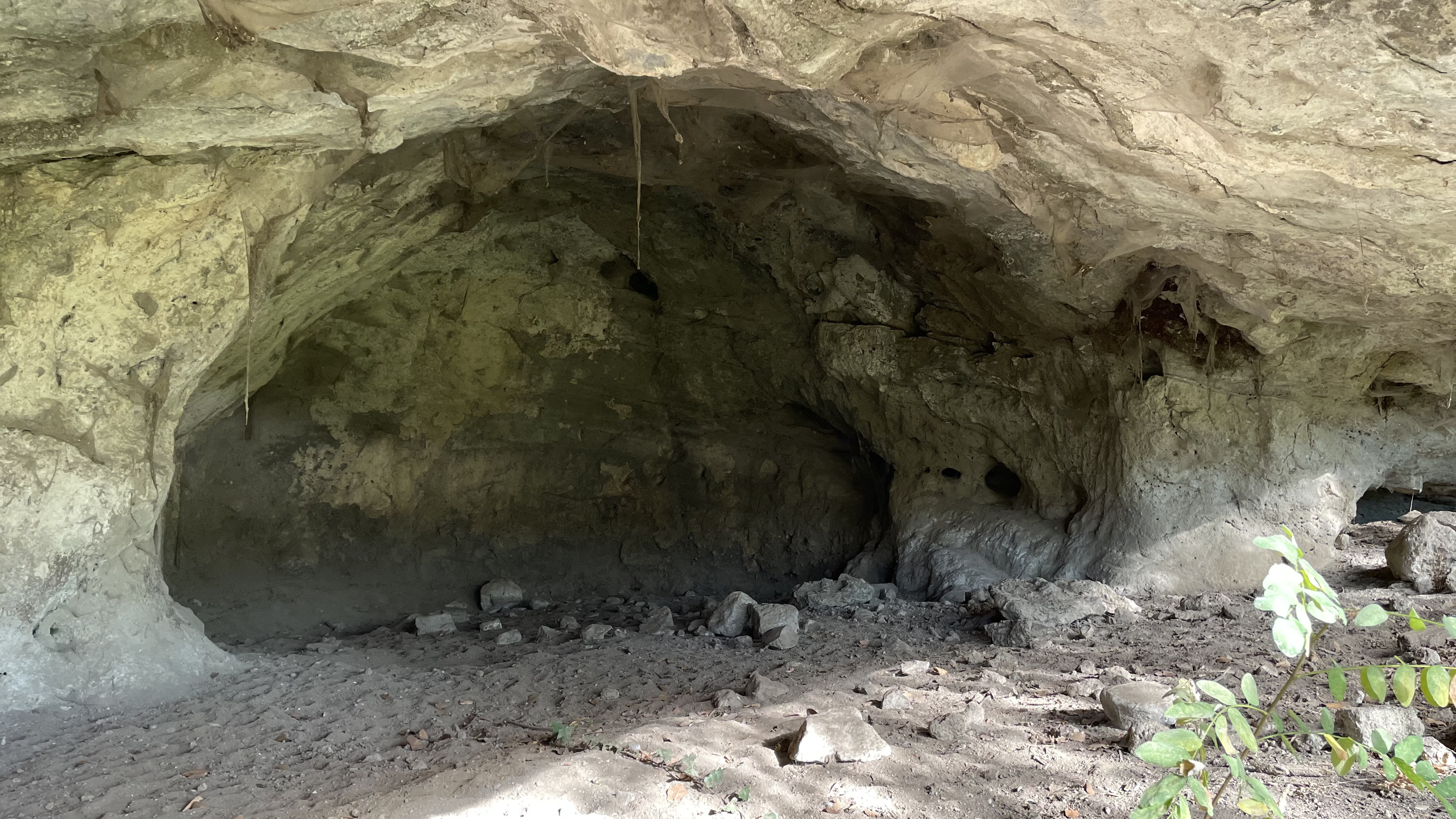
I also noticed a small, maybe 3-meter wide shelter cave in the cliffs around Lago Albano. Let's call it the Minuscola Grotta al Lago (N 41.738764 E 12.660339).

Here are some pictures also from Caste Gandolfo and Lago Albano:

And Lago di Nemi:

Read more urban exploration stories from theurbanexplorer.net, and other underground stories from planetcaver.net. Read the full Planetskier series at planetskier.net, or all blog articles from Blogspot or TGR. Photos and text (c) 2023 by Jari Arkko. All rights reserved. 

Grani slope opening day

In 2023, the Grani ski slope opened on 2nd of December. I walked to the hill, a nice experience in the cold morning weather. And I feel lucky for having a ski hill within walking distance, maybe a bit over a kilometer away. On the way back (unless the roads are sanded) it is also downhill, so I can ski big parts of it.

Video:

Photos:

Me walking to the slope:

Skiing home on the roads:

Read the full Planetskier series at planetskier.net, or all blog articles from BlogspotTGR. Photos, videos, and text (c) 2023 by Jari Arkko.

Riihivuori, what a nice place to ski at!


Coming back from my visit at the bat cave headquarters, I was faced with a choice: drive straight home with my crappy car and minimize risk of breakdown? Or detour extra two hours via Jyväskylä and visit the a ski hill that I've never been on, Riihivuori? They had just opened... in the end I took the risk. And wow, was it worth it!

Not only was my car alright in the end, but Riihivuori was just a wonderful place. I was there just an hour before closing, and sales agent worked me a happy discount. And when I said that I was collecting ski areas, and asked for lift map, they said they don't have one. But then later they run after me and gave me a some clothing with their signage. Nice! And lift boy knew everyone going through the lift, and asked if I had just arrived. 

All in all, such a great experience with friendly people. I didn't have time to stay for the restaurant, but for what it is worth, it looked a very nice one for a ski resort cafeteria. And with cleanest and nicest bathrooms I've basically ever seen in any ski resort! Again, well done. Not all the slopes were open yet, just a kiddie slope, actually -- they had just opened, and that's why I was here. I should stay here later in the winter, even for a couple of nights. The bigger slopes looked very promising.


What they gave me:


Read the full Planetskier series at planetskier.net, or all blog articles from BlogspotTGR. Photos, videos, and text (c) 2023 by Jari Arkko.

Thursday, November 23, 2023

Night at the batcave headquarters

What a wonderful experience, pre-Xmas party with my caver friends, in a Lava (angled shelter by the fire) and Palju (a barrel of hot water). What could be better? Oh yeah, we had also interesting talks about explorations in Norway, Turku, and ... also our own Käsivarsi exploration in the summer.

If you're interested in these experiences, join the caving club here.

But back to the Laavu. It is the bat cave headquarters. Or.. wait is this the Darth Vader helmet?


I see it at least as such. But that as it may, we needed to grill some sausages and the Dark Helmet is perfect for that :-)


And there was a Palju, the hot water barrel. You fill it with cold water and then heat with fire underneath. Wonderful experience in the minus degrees, darkness, and the Laavu lights.


But the truly amazing thing of course was that my managed to not break down on the way here (4 hours) or back (6 hours, via skiing)!


Read more urban exploration stories from theurbanexplorer.net, and other underground stories from planetcaver.net. Read the full Planetskier series at planetskier.net, or all blog articles from Blogspot or TGR. Photos and text (c) 2023 by Jari Arkko. All rights reserved. 

Thursday, November 16, 2023

Day of caving but no luck

I had great plans, but they all failed. Either the caves I visited turned out to be man-made, they were too small and I had to let them go, I didn't find them, or I arrived to late and they were already closed. So much for my effort to visit five new caves on my way from the conference to the airport. 

There's also some wonderful areas, full of holes in rocks... and look at some of the houses built in these areas, e.g., in the picture above.

Below are the caves that I visited, in what I think was sandstone in all cases:

Jeskyné Klemperka, in Kokořín, Czech Republic. This is likely an originally natural cave that was significantly enlarged by man. The nice thing about this cave was that you needed a ladder to reach the entrance. One was provided. Nice! Coordinates: N 50.437637 E 14.554619.

The cave is on a crack in a ledge, but the cave continues directly into the cliff by one room which is probably man-made. The ledge was probably enlarged by man as well. Then there's stairs to a lower level which has one very large room. And apparently some bats, at least according to the sign.


Jeskyné Klemperka underground hole. A small pit, a hole under the cliff and under the ground level. Looks natural, not man-made. Maybe 2 meters long. Coordinates: N 50.438349 E 14.554954.

Jeskyné Klemperka side apartment. This fifty meters further north on the road and on the other side. It looks mostly man-made, though perhaps there's been a crack that they started enlarging. This is like a ground-level apartment with few small rooms. There was also a second level hideout inside the crack. Very small. Coordinates: N 50.438382 E 14.554900.

Kokořín shelter cave 1. Well this is entirely natural, but it is tiny, maybe 6-7 meters across and 2 meters under the roof. Coordinates: N 50.442271 E 14.552615.

Kokořín shelter cave 2. This is also entirely natural, a roof that has formed in front of a cliff, roughly half-way up but easily reachable. This is also maybe 6-7 meters long, and perhaps 3 meters under the roof. But a bit more open. However, there's a nice separate bolder sitting on the ledge, and holding the roof up. Coordinates: N 50.442155 E 14.552186.

Jeskyné Rozbořenka. This is entirely man-made I think. A magnificent set of massive stone blocks, and then they've turned the lowest level of the blocks into apartments :-) Interesting, but definitely weird. And ... someone was living in there. Coordinates: N 50.443150 E 14.551614.

Jeskyné Wernerovka, Medonosy-Libéchov. Again, entirely man-made (except maybe for the little horizontal crack in the second level. A smallish rock outcrop made into a two-room apartment. Coordinates: N 50.502520 E 14.529695. Some articles: KudyznudyNavylet.

Wernerovka firepit shelter cave. There were a few cave-like things but too small near the Wernerovka cave. This one is a nice camping spot and a fire pit, right under a very high but shallow negative rock face. Not that I'd necessarily put any fire under any rock, even if the rock is high... rock cracks with heat. Coordinates: N 50.503227 E 14.531643.

Wernerovka mini cavelet. A little mini-canyon between two rock outcrops and some boulders on top makes for a small cave. Maybe 5 meters long. Access on a very steep dirt face covered by half a meter of leaves. Difficult to get in. Coordinates: N 50.502543 E 14.531230.

Konépruské Jeskyné, Konéprusy. A massive commercial cave. But I arrived twenty minutes after they had closed the entrance for the day. Oh well. Maybe next time. Coordinates: N 49.915136 E 14.067413. Read more about this from the official site or Wikipedia.

(The above photo is by Zp in Wikipedia)

Kodska Jeskyné, Srbska. On a very steep hill with thick bushes. I was unable to find it, despite circling around both of the coordinates that I knew about. Oh well. I might have found it with more time, but I felt uneasy about the hill and my descent from there; the whole thing was too steep really to safely be there, at least in the rain that was coming down. Slippery leaves. Coordinates: N 49.933078 E 14.125004 (Wikipedia) or N 49.932939 E 14.124656 (Google Maps). However, later I realized that the Tourismato site points the cave to a different side of the valley. Maybe those are the right coordinates?

Read more urban exploration stories from theurbanexplorer.net, and other underground stories from planetcaver.net. Read the full Planetskier series at planetskier.net, or all blog articles from Blogspot or TGR. Photos and text (c) 2023 by Jari Arkko. All rights reserved. Konépruské photo by Zp, CC BY-SA 3.0.